Mountain range, region / State
Maglić (pohoří) / Bosnia and Herzegovina
Season
Summer
10. 08. - 13. 08. 2010
Difficulty
3 / 5
Elevation
↑ 2799 m
↓ 2799 m
Length
30.8 km
4 days
Altitude
max. 2386 m n.m.
min. 698 m n.m.
Tourist map of Maglic Mountains
Elevation profile of the route
Useful information
- 10.8. - arrival to the village of Mratinje, climbing through the dense forest into the mountains. Crossing to the Carev Do mountain cauldron, finding a water spring, overnight.
- 11.8. - easy ascent to Bosensky Maglic and return to the tent. Descent to Trnovacka lake, overnight at the lake.
- 12.8. - path from Trnovacka lake to Prijevor saddle, continuation of the path in the upper part of Peručica forest and then under Maglic mountains turn to the plain. Crossing the plain and under the hill building a tent at the former Polica shepherd's huts.
- 13.8. - from the Polica shepherd's huts return along the trail through the dense forest to the village of Mratinje. Departure to the sea.
Four-day mountain cicrle hike in Bosnia
Starting point
The village of Mratinje, south of the Maglic Mountains, is reached by road from the Piva River. We left the car in an uncle's yard. He willingly offered us parking and even lent us an old military map of the mountains.
Description of the hike
1. day
Our wandering in the Maglic Mountains began with our arrival in the village of Mratinje. We moved here from the Durmitor mountain pass we had crossed in the previous days. The village of Mratinje lies on the other side of the Piva Dam from the Durmitor mountain range. The parking dilemma took its toll when an elderly uncle opened the gate to the garden and let us park there. In addition, he lent us a map of the mountains and arranged a guide through the dense forest to the Maglic Mountains.
So from the village we set off into the dense forest with the assistance of a local grandmother spice farmer and her granddaughter. Unfortunately, I am not able to describe exactly which way the path led, because the paths were narrow and constantly changed direction. After about 1 hour of walking, our escort left us and we immediately got lost. Luckily we came across a trail that had the right direction and so we were lucky to get above the tree line and continued into the Maglic Mountains.
The trail continued on, first through scrub and then switching to mountain terrain, a combination of grass and rocks. Eventually we left the trail and ascended to the plateau through open terrain. We continued along it towards the Carev Do mountain basin. We descended into it and were horrified to find that the water source was dry. Fortunately, we managed to find another spring in the hillside and so we pitched our tent and spent the night there.
2. day
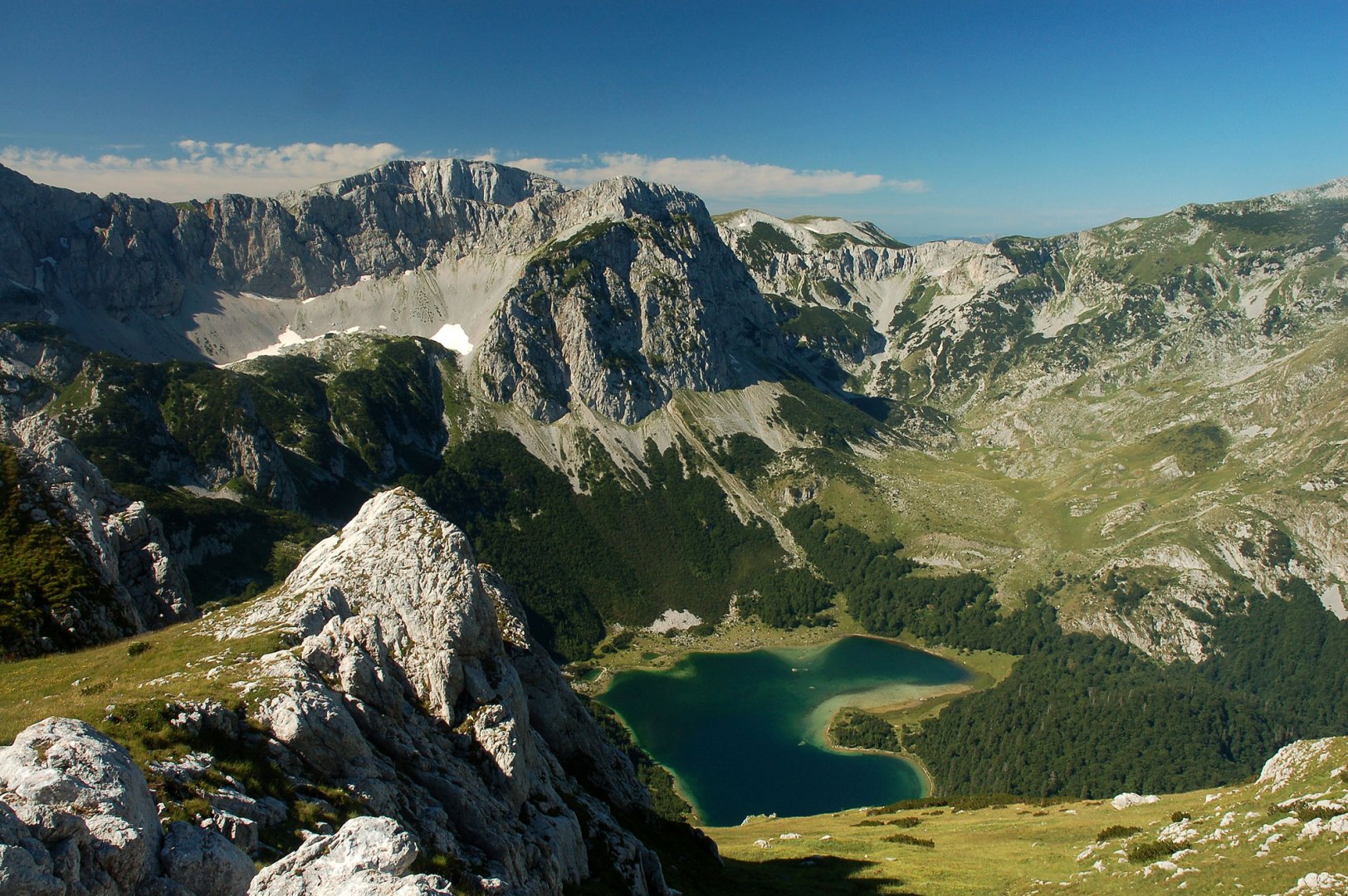
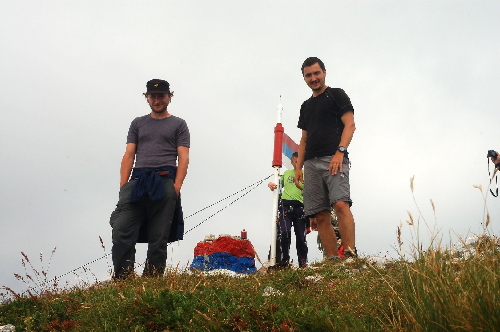
In the morning the mountains appeared to us in their full glory. The clouds below us, the sunrise. At the same time we saw for the first time the beautifully situated Trnovačko lake, where we wanted to spend another night. But today's goal was to climb Bosnian and Montenegrin Maglic 2 386 m above sea level. We left our tent in place and varazed lightly along the wide ridge towards the peaks.
There was a well-trodden path, so the way passed quickly. We climbed both peaks without any problems. Especially on Bosnian Maglice there were quite a lot of people. It is the highest mountain in Bosnia and Herzegovina. And it was mainly here that the special unit from Sarajevo was training.
From the top we went back to the tent the same way. Here we rested and started descending on the trail to the Trnovačko lake. The descent was easy and soon we were swimming in the lake. It was great. We pitched our tent by the lake and spent another night there.
3. day
In the morning we replenished our water supplies at the lake and set off along the trail towards the Prijevor saddle. From the lake there was a narrow trail at first, but it widened over time and by the saddle it was a wide dirt road. Here we also reached the upper part of the Peručica forest. After this wide path we turned east and passed under Bosenská Maglic.
When we got beyond the level of the main ridge of the Maglic Mountains, we turned off the wide road to the south and crossed onto a plain. Around the main ridge of the mountain range we continued on the open ground on the plain back towards the village of Mratinje. After the plateau we reached its rock break. As we did not encounter water anywhere, we descended along the trail into the forest to the former Polica shepherd's huts. Here we finally found water and so we spent the night. Even with a slight fear of a visit from bears.
4. day
We successfully survived the night and continued along the trail back to the village of Mratinje. In these places the trail was already clearly legible and so there was no problem with orientation. Moreover, we came across a local hikers' club who were renewing the hiking signs.
We were warmly welcomed in the village and to celebrate our return most of our expedition had to get drunk with the local natives. This was followed by a return to the homeland. We wanted to enjoy a bit of the sea as well, so we headed up the coast to the beautiful Boka Kotorska bay. We had a well-deserved bath in Croatia and then it was back home for good.
Difficulty
An tough hike in wild nature untouched by human activity. The hike is difficult, so all equipment must be brought with you. The main problem is orientation. When we were here, there was no good map of the mountains available. We finally got help from a local uncle who lent us an old military one. It's mostly off-trail, so it's good to have experience navigating in the mountains.
Water availability
You have to get water in the village, the next spring is in the Carev do cauldron below the ridge that leads to the main peak. Another spring is at the Trnovačko lake. The last water we got was at the former Polica shepherd's huts, where we slept the last night.
Sleeping options
We spent the first night in the Carev do mountain cauldron, where we found a water spring. The next night was at Lake Trnovačko. The last bivouac was at the former shepherd's huts Polica, where there was also water.
Mountain peaks
From the peaks Černohorský Maglic 2 388 m above sea level and Bosenský Maglic 2 386 m above sea level there are beautiful views of the surrounding mountains - Bioč and Volujak.
Danger
When you observe safety in the mountains, it is not a problem to take this tour. It is mostly off trail, but there are no dangerous spots. In the local forests there is a risk of encountering a bear or stepping on a viper. That's why it's a good idea to make more noise. We were stomping and fake singing. On our last night we hung our food in a tree far from our tent in case a bear got a taste for our food.
Food
There is no tourist lodge on the trek, so it is necessary to have all supplies with you. We cooked our food on gas cookers.
Attractions
Maglic is one of the three mountain ranges enclosing Lake Trnovačko (the other two are Volujak and Bioć). In the Maglic mountain range you are sure to meet no one, except the highest mountain of the same name and the Trnovačko lake. There were some drawbacks, mainly due to orientation, as it was difficult to find even a bit of beaten path. The inhabitants of the village of Mratinje helped us a lot.
We left our car parked in one uncle's garden. He also lent us an old military map, which we could use to at least partially orient ourselves. In addition, a local grandmother showed us at least part of the way through the dense forest to the mountains. And when we successfully returned, we were of course pleasantly drunk.
Photos