Mountains Chřiby
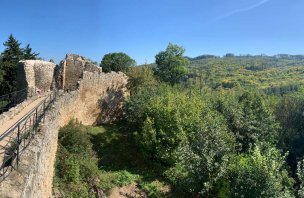
Chřibská vrchovina is located about 50 km east of Brno, between Kyjov and Otrokovice. The Chřiby Upland is about 35 km long and the highest mountain Brdo is 587 m above sea level. The Chřiby Mountains are densely covered with a carpet of mainly beech forests, in which we can find the remains of forgotten fortifications from the ancient times of Great Moravia (for example, the national cultural monument "Svatý Kliment").
The famous pilgrimage site associated with the Great Moravian Empire, Velehrad, is also located in close proximity to the Chřiby Uplands. The Chřiby Mountains also dominated the ancient Amber Trail, which ran along the Morava River from the Adriatic Sea to the Baltic Sea. Nowadays, the Chřiby Nature Park and several nature reserves have been destroyed here - for example, Holý Kopec, Moravanské lúky, Smutný žleb, Stará hráz and Záskalí.
In addition to nature reserves, there are many natural monuments and interesting rock formations marked on the map for the curious tourist, e.g. Čertovy skály, Barborka, Ježovský lom, Máchova dolina, etc. A large number of watercourses, such as the Kyjovka (called Stupava in Chřiby), Litava, Kotojedka or Dlouhá řeka, originate in the territory of Chřiby. The name Chřiby probably originates from the Old Czech "chřib" - hill, or from the term "grib" - rock, hill, which was formerly used in the surrounding European countries. From the Middle Ages you can visit the ruins of Cimburk, Střílky or one of the oldest castles in Moravia, Buchlov.
The highest mountain
Brdo 578 m
List of major mountain peaks
Vlčák 569 m, Jílová 544 m, Hrad 552 m, Holý kopec 548 m, Bradlo 543 m
Chřiby is divided
Protected areas
Chřiby Nature Park
More information
It belongs to the system Central Moravian Carpathians
It is in the Czech Republic
Predominant rocks: flysch
